Introducing MAReS: a warning service for harmful algae-blooms
Share:
Go to:
Harmful algae blooms challenge Costa Rica’s coastal ecosystems and with them, national aquaculture and the tourism economy.
Water Insight and its consortium partners are trying to address this problem. Their aim? To provide a scalable early warning service. Project leader and Water Insight’s Director, Marnix Laanen, shared the ins and outs of their innovative solution. “This way of monitoring and measuring algae blooms has never been done before in Costa Rica.”
Project leader
“Measuring water quality with satellite imagery and spectrometers provides instant, efficient and enduring data,” explains Marnix. He works on the MAReS pilot project alongside Costa Rican consortium partners Universidad Nacional and Kaune Engineers & Architects SRL. Together, they detect and monitor Harmful Algae Blooms (HABs) along the Costa Rican Pacific coastline, up to 1000 Kilometres into the ocean, using remote sensing technology. “This isn’t the first time Water Insight is collaborating with Partners for Water,” Marnix shares. “In 2012, we tested one of our portable WISP-3s (Water Insight Spectrometer) devices to monitor surface water quality in Estonia, and we were honoured with the Partners for Water Award.”
This time, more than just a product is being tested. “We aim to create a scalable service that provides near-real-time and spatial insights into the location of the HABs to offer local economic sectors the ability to mitigate. Next to contributing to the Costa Rican economy, the project also supports SDG 6: Clean Water and Sanitation, and SDG 13: Climate Action.”
Transforming challenges into innovations
The increasing threat of HABs jeopardises the rich coastal ecosystems of Costa Rica and crucial economic sectors such as tourism and aquaculture. “The principal cause of HABs is a mixture of eutrophication and climate change,” says Marnix. “They imperil the water quality and all living organisms because they can contaminate the water with toxins and cause anoxia.” By offering a real-time data and prediction service, the consortium aims to assist end-users with timely warnings about the location of HABs, enabling them to anticipate and relocate activities to uncontaminated sites. “For instance, fish farmers may opt to harvest extra fish before the HAB arrive in order to continue delivery, or diving schools can select alternative spots for tourist dives.”
Before these real-time maps are ready to be used, a substantial amount of data must be collected and tested. “With the help of satellite images, we measure the colour of the water. This data is validated through colour measurements from local WISPstations positioned in the water. With this data, we can provide an indication of current or future algal blooms,” explains Marnix. During the pilot project, the WISP data will be verified through water sample testing by researchers from the consortium partner Universidad Nacional. “The combination of using satellite data, calibrated and continuously validated by a WISPstation, is quite a unique method of measuring algae bloom. And it has never been done before in Costa Rica.”
Consortium partners & local partners
“Working with local partners is crucial for a project like this,” Marnix explains. “We were fortunate to catch the attention of one of our local consortium partners, Kaune Engineers & Architects. They reached out to us and the Universidad Nacional, brought our consortium together, and connected us with two Costa Rican companies that are willing to co-design and ultimately adopt the service.” Marnix shares that they use the so-called ‘agile’ approach. “Through regular meetings and feedback sessions with the end user, we are flexible in making decisions and designing the final product. It makes it easier to implement changes that optimise the service for the end user.”
Next step
“At present, the data from the WISPstation is being validated using water sample measurements,” Marnix shares. “And we are discussing the images we generate from the real-time data with the end users.” He explains: “First of all, to verify that the images correspond with their experiences of the algae bloom, but also to receive feedback on the visual presentation of the data. Because ultimately, we want the end users to have an accurate and usable map to support their mitigation decisions.”
Innovation in progress series
During the Partners for Water 2022 – 2027 programme, several projects that received the Partners for Water subsidy will be followed from start to finish. Over the next few years, they will take you with them on their transformative journey. You’ll be able to gain insights into their promising solutions, innovative processes and collaborations with local partners, as well as their struggles, challenges and valuable lessons learned. Stay tuned and follow their journey through the Partners for Water website and our LinkedIn page!
Related news

Dutch - Indonesian water sector event: looking back at positive results from bilateral collaborations
Full article
Two multidisciplinary teams have been selected to become part of Water as Leverage Cartagena
Full article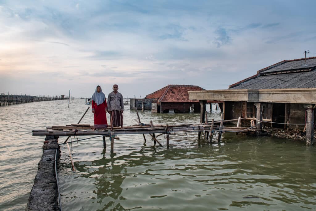
Join our exchange session on Dutch – Indonesian water cooperation
Full article
Partners for Water is a Dutch government programme that works on solving water issues around the world. We do this through longterm cooperation with local partners and the Dutch water sector. We encourage knowledge exchange, innovation and an integrated approach. This is how we make an impact in the field of water security for people, plants and animals.